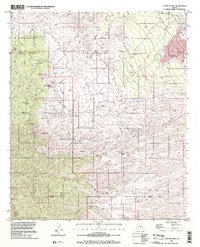
1996 Map of Campo Bonito
USGS Topo · Published 2002About this map
Oracle Ridge and the Santa Catalina Mts dominate this landscape where the high desert meets mineral-rich foothills. The topography traces a legacy of hard-rock mining and ranching, centered on the settlement of Campo Bonito and the developed area of San Manuel. Evidence of early industrial activity is etched across the terrain, from the Smelter near American Flag Ranch to numerous workings like the Highjinks Mine and Southern Belle Mine.
Find a feature on this map
41 named features on this map. Tap any name to fly to it.
Don’t see what you’re looking for? This feature index may not catch every label — zoom into the map to look around manually.
Map Details
Editions of this 1996 Campo Bonito Map
This is the sole edition of this map. No revisions or reprints were ever made.
Other maps of this area

1904 · Tucson
USGS Topo · 1:125,000

1905 · Tucson
USGS Topo · 1:125,000

1911 · Winkelman
USGS Topo · 1:125,000

1913 · Winkelman
USGS Topo · 1:125,000

1948 · Clark Ranch
USGS Topo · 1:24,000

1948 · Mammoth
USGS Topo · 1:62,500

1948 · Mammoth
USGS Topo · 1:24,000

1948 · Campo Bonito
USGS Topo · 1:24,000

1948 · Peppersauce Wash
USGS Topo · 1:24,000

1949 · Clark Ranch
USGS Topo · 1:24,000