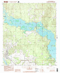
1996 Map of Campti
USGS Topo · Published 1999About this map
Black Lake and Clear Lake dominate this portion of the Red River Valley, where the complex hydrology of the Louisiana bayous creates a landscape of interconnected sloughs and brakes. The eastern shore of the lake is punctuated by family and community landmarks, including Our Lady of the Rosary Ch and Black Lake Ch. Further inland, the settlement of Creston and the New Mount Zion Ch stand near the edge of the Natchitoches Parish line, while the southern reaches near Bourbeaux show the influence of industrial activity within an Oil and Gas Field.
Find a feature on this map
42 named features on this map. Tap any name to fly to it.
Don’t see what you’re looking for? This feature index may not catch every label — zoom into the map to look around manually.
Map Details
Editions of this 1996 Campti Map
This is the sole edition of this map. No revisions or reprints were ever made.
Other maps of this area

1937 · Campti NE
USGS Topo · 1:31,680

1937 · Campti SE
USGS Topo · 1:31,680

1937 · Campti NW
USGS Topo · 1:31,680

1937 · Campti SW
USGS Topo · 1:31,680

1944 · Campti
USGS Topo · 1:62,500

1947 · Goldonna
USGS Topo · 1:62,500

1947 · Ashland
USGS Topo · 1:62,500

1948 · Campti
USGS Topo · 1:62,500

1949 · Calvin NW
USGS Topo · 1:31,680

1949 · Calvin SW
USGS Topo · 1:31,680