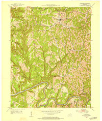
1952 Map of Campton
USGS Topo · Published 1954About this map
The town of Campton sits at a high point in this 1952 study, where KY 15 intersects the local ridge network of Wolfe County. The landscape is defined by the deeply incised valleys of the North Fork Kentucky River to the south and the Red River headwaters in the north, with the Cumberland National Forest covering the northwestern corner. The interior is dotted with localized community centers, often consisting of a named schoolhouse or mission station serving remote hollows along Swift Creek and Devil Creek.
Find a feature on this map
57 named features on this map. Tap any name to fly to it.
Don’t see what you’re looking for? This feature index may not catch every label — zoom into the map to look around manually.
Map Details
Editions of this 1952 Campton Map
This is the sole edition of this map. No revisions or reprints were ever made.
Other maps of this area

1889 · Salyersville
USGS Topo · 1:125,000

1891 · Salyersville
USGS Topo · 1:125,000

1892 · Beattyville
USGS Topo · 1:125,000

1899 · Salyersville
USGS Topo · 1:125,000

1951 · Landsaw
USGS Topo · 1:24,000

1951 · Hazel Green
USGS Topo · 1:24,000

1951 · Pomeroyton
USGS Topo · 1:24,000

1951 · Jackson
USGS Topo · 1:24,000

1952 · Slade
USGS Topo · 1:24,000

1952 · Tallega
USGS Topo · 1:24,000