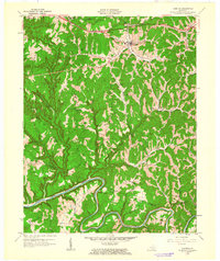
1961 Map of Campton
USGS Topo · Published 1963About this map
Campton serves as the focal point of this 1961 revision, situated where the Mountain Parkway meets KY 15 in the northern portion of the quadrangle. The landscape is defined by the deep dissection of the North Fork Kentucky River, which meanders across the southern boundary, creating a complex network of ridges and hollows. Local commerce and connectivity are evident in the presence of scattered Mines and an Oil Well near Vertex, while the rural character is preserved through numerous family and community landmarks. Researchers will find a wealth of educational history via small country schools such as Tar Ridge Sch, Quillins Chapel Sch, and Bloody Creek Sch. The terrain transitions from the protected lands of Cumberland National Forest in the northwest to concentrated settlement at Hiram and Hurst. Spiritual life is anchored by Quillins Chapel and Bethesda Mission, reflecting the social structure of these Wolfe County communities during the early 1960s.
Find a feature on this map
53 named features on this map. Tap any name to fly to it.
Don’t see what you’re looking for? This feature index may not catch every label — zoom into the map to look around manually.
Map Details
Editions of this 1961 Campton Map
This is the sole edition of this map. No revisions or reprints were ever made.
Other maps of this area

1889 · Salyersville
USGS Topo · 1:125,000

1891 · Salyersville
USGS Topo · 1:125,000

1892 · Beattyville
USGS Topo · 1:125,000

1899 · Salyersville
USGS Topo · 1:125,000

1951 · Landsaw
USGS Topo · 1:24,000

1951 · Hazel Green
USGS Topo · 1:24,000

1951 · Pomeroyton
USGS Topo · 1:24,000

1951 · Jackson
USGS Topo · 1:24,000

1952 · Slade
USGS Topo · 1:24,000

1952 · Tallega
USGS Topo · 1:24,000