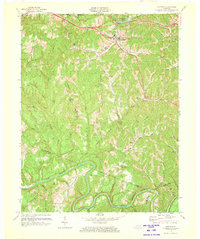
1972 Map of Campton
USGS Topo · Published 1973About this map
The town of Campton serves as the focal point of this 1970s topographic survey, situated at the intersection of the Mountain Parkway and a network of winding mountain roads. The landscape is defined by the deep dissection of the Cumberland Plateau, with prominent elevations like Tar Ridge and Sandy Ridge separating the numerous creek valleys. To the south, the North Fork Kentucky River meanders sharply through the terrain, joined by tributaries such as Bloody Creek and Upper Devil Creek.
Find a feature on this map
56 named features on this map. Tap any name to fly to it.
Don’t see what you’re looking for? This feature index may not catch every label — zoom into the map to look around manually.
Map Details
Editions of this 1972 Campton Map
This is the sole edition of this map. No revisions or reprints were ever made.
Other maps of this area

1889 · Salyersville
USGS Topo · 1:125,000

1891 · Salyersville
USGS Topo · 1:125,000

1892 · Beattyville
USGS Topo · 1:125,000

1899 · Salyersville
USGS Topo · 1:125,000

1951 · Landsaw
USGS Topo · 1:24,000

1951 · Hazel Green
USGS Topo · 1:24,000

1951 · Pomeroyton
USGS Topo · 1:24,000

1951 · Jackson
USGS Topo · 1:24,000

1952 · Slade
USGS Topo · 1:24,000

1952 · Tallega
USGS Topo · 1:24,000