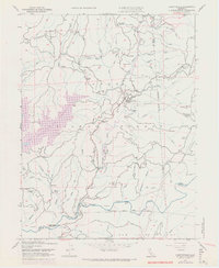
1948 Map of Camptonville
USGS Topo · Published 1971About this map
Camptonville stands as a central point of settlement in this landscape within the Tahoe National Forest, where the transition from mid-century ranching to modern water management is visible. The map documents the presence of New Bullards Bar Reservoir, a major geographic shift that altered the drainages of Mill Creek and surrounding gulches. Family history is etched into the terrain through numerous named properties such as Pendola Ranch, Schnellman Ranch, and Kennedy Ranch, alongside established landmarks like the Sleighville House.
Find a feature on this map
71 named features on this map. Tap any name to fly to it.
Don’t see what you’re looking for? This feature index may not catch every label — zoom into the map to look around manually.
Map Details
Editions of this 1948 Camptonville Map
4 editions found
Other maps of this area

1888 · Smartsville
USGS Topo · 1:125,000

1888 · Bidwell Bar
USGS Topo · 1:125,000

1891 · Bidwell Bar
USGS Topo · 1:125,000

1891 · Downieville
USGS Topo · 1:125,000

1891 · Colfax
USGS Topo · 1:125,000

1891 · Smartsville
USGS Topo · 1:125,000

1892 · Smartsville
USGS Topo · 1:125,000

1892 · Colfax
USGS Topo · 1:125,000

1893 · Bidwell Bar
USGS Topo · 1:125,000

1893 · Downieville
USGS Topo · 1:125,000