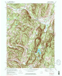
1973 Map of Canaan
USGS Topo · Published 1985About this map
New Lebanon and Canaan dominate this 1970s landscape, situated along the winding paths of Kinderhook Creek and Wyomanock Creek. The map documents a corridor of significant local institutions and recreation, from the Lebanon Valley Speedway in the northwest to the Berkshire Farm For Boys and the Mt Lebanon Darrow Sch near the Massachusetts state line. This era captures the transition of the region's transport networks, where the Penn Central railroad lines and the New York Thruway (Berkshire Section) cross through the valley. Residential and historical sites are densely mapped, including the Cemetery of the Evergreens and several smaller burial grounds like the Cornwall-Tilden Cem. The presence of Shaker Swamp and Queechy Lake highlights the significant water features that have long influenced settlement patterns in these Taconics foothills.
Find a feature on this map
38 named features on this map. Tap any name to fly to it.
Don’t see what you’re looking for? This feature index may not catch every label — zoom into the map to look around manually.
Map Details
Editions of this 1973 Canaan Map
4 editions found
Other maps of this area

1888 · Berlin
USGS Topo · 1:62,500

1888 · Pittsfield
USGS Topo · 1:62,500

1890 · Pittsfield
USGS Topo · 1:62,500

1890 · Berlin
USGS Topo · 1:62,500

1893 · Troy
USGS Topo · 1:62,500

1893 · Pittsfield
USGS Topo · 1:62,500

1894 · Berlin
USGS Topo · 1:62,500

1894 · Pittsfield
USGS Topo · 1:62,500

1895 · Troy
USGS Topo · 1:62,500

1897 · Pittsfield
USGS Topo · 1:62,500