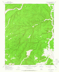
1964 Map of Canaan Creek
USGS Topo · Published 1966About this map
Dixie National Forest defines this high-desert landscape in Garfield County, where the 1964 topography reveals a complex network of drainage systems and early industrial markers. The terrain is characterized by deep incisions like Coal Bed Canyon and Mitchell Canyon, which feed into larger arteries such as Alvey Wash. Water is the primary architect here, with Upper Valley Creek and Canaan Creek carving paths through the central and northern sections of the quadrangle. While largely an expanse of natural features, the presence of an Oil Well and a Prospect indicates the era's ongoing exploration for subsurface resources. High-altitude plateaus like Cherry Flat provide contrast to the narrow creek beds and the numerous unnamed canyons that segment the forest, illustrating the land's transition between elevated flats and the wash-riddled lowlands typical of south-central Utah.
Find a feature on this map
16 named features on this map. Tap any name to fly to it.
Don’t see what you’re looking for? This feature index may not catch every label — zoom into the map to look around manually.
Map Details
Editions of this 1964 Canaan Creek Map
2 editions found
Other maps of this area

1886 · Escalante
USGS Topo · 1:250,000

1956 · Escalante
USGS Topo · 1:250,000

1960 · Escalante
USGS Topo · 1:250,000

1964 · Griffin Point
USGS Topo · 1:24,000

1964 · Dave Canyon
USGS Topo · 1:24,000

1964 · Canaan Creek
USGS Topo · 1:24,000

1964 · Canaan Peak
USGS Topo · 1:24,000

1964 · Death Ridge
USGS Topo · 1:24,000

1964 · Carcass Canyon
USGS Topo · 1:24,000
1964 · Wide Hollow Reservoir
USGS Topo · 1:24,000