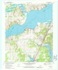
1971 Map of Canadian
USGS Topo · Published 1988About this map
Eufaula Reservoir dominates the landscape in this early 1970s survey, its waters reaching into the hills of the Burton area and surrounding Sams Point. The map captures the infrastructure of Pittsburg County during a period of transition, where the Missouri Kansas Texas railroad line runs parallel to an Old Railroad Grade, tracing the evolution of transport through the valley. Along the eastern shore, Arrowhead State Park is shown with its early development, including a campground and proximity to the community of Canadian.
Find a feature on this map
30 named features on this map. Tap any name to fly to it.
Don’t see what you’re looking for? This feature index may not catch every label — zoom into the map to look around manually.
Map Details
Editions of this 1971 Canadian Map
2 editions found
Other maps of this area

1900 · Canadian
USGS Topo · 1:125,000

1946 · Fort Smith
USGS Topo · 1:250,000

1962 · Raiford
USGS Topo · 1:24,000

1963 · Stidham
USGS Topo · 1:24,000

1963 · Eufaula
USGS Topo · 1:24,000

1965 · Fort Smith
USGS Topo · 1:250,000

1967 · Fort Smith
USGS Topo · 1:250,000
1971 · Blocker
USGS Topo · 1:24,000
1971 · Crowder
USGS Topo · 1:24,000
1971 · Canadian
USGS Topo · 1:24,000