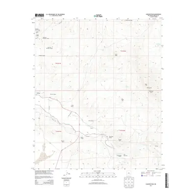
2013 Map of Canador Peak
USGS Topo · Published 2013About this map
The Virden settlement serves as the primary western gateway to this New Mexico landscape, where the Gila River snakes through the high desert. Irrigation infrastructure is central to the area's development, evidenced by the intricate paths of the Sunset Canal and New Model Canal that parallel the river's course to support local agriculture. The topography is defined by significant volcanic and erosional landmarks such as Canador Peak and Black Mtn, alongside the deeply carved Gila Lower Box canyon. Numerous family-named canyons, including Riley Canyon and Hughs Canyon, together with natural water sources like Riley Spring and Mexican Springs, indicate a history of ranching and territorial land use. The elevation shifts significantly from the river bottom up to Pearson Mesa, providing a detailed look at the geographic transition between the valley floor and the surrounding high country peaks.
Find a feature on this map
38 named features on this map. Tap any name to fly to it.
Don’t see what you’re looking for? This feature index may not catch every label — zoom into the map to look around manually.
Map Details
Editions of this 2013 Canador Peak Map
This is the sole edition of this map. No revisions or reprints were ever made.
Other maps of this area

1954 · Silver City
USGS Topo · 1:250,000

1958 · Silver City
USGS Topo · 1:250,000

1959 · Steeple Rock
USGS Topo · 1:62,500

1959 · Canador Peak
USGS Topo · 1:62,500

1959 · York Valley
USGS Topo · 1:62,500

1960 · Duncan
USGS Topo · 1:62,500

1962 · Silver City
USGS Topo · 1:250,000
1986 · Duncan
USGS Topo · 1:24,000
1986 · Round Mountain
USGS Topo · 1:24,000
1986 · Goat Camp Spring
USGS Topo · 1:24,000