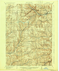
1916 Map of Canaseraga
USGS Topo · Published 1931About this map
Canaseraga and its surrounding hill country define this landscape, where the northern drainage of Canaseraga Creek meets the rugged divide of the southern Tier. The early twentieth-century transport network is dominated by the heavy presence of the Erie RR and the Pittsburgh Shawmut and Northern railroads, which carved routes through the high terrain to connect settlements like Swain and Whitney Crossings Garwoods Sta.
Find a feature on this map
61 named features on this map. Tap any name to fly to it.
Don’t see what you’re looking for? This feature index may not catch every label — zoom into the map to look around manually.
Map Details
Editions of this 1916 Canaseraga Map
4 editions found
Other maps of this area

1902 · Wayland
USGS Topo · 1:62,500

1904 · Wayland
USGS Topo · 1:62,500

1905 · Portage
USGS Topo · 1:62,500

1905 · Nunda
USGS Topo · 1:62,500

1906 · Angelica
USGS Topo · 1:62,500

1915 · Hornell
USGS Topo · 1:62,500

1916 · Canaseraga
USGS Topo · 1:62,500

1918 · Hornell
USGS Topo · 1:62,500

1925 · Belmont
USGS Topo · 1:62,500

1926 · Wellsville
USGS Topo · 1:62,500