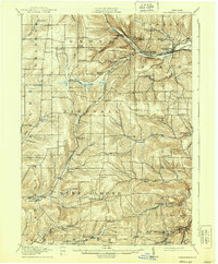
1916 Map of Canaseraga
USGS Topo · Published 1939About this map
Canaseraga and its surrounding hill country are defined by a complex network of deep valleys and winding waterways in this early twentieth-century survey. The northern edge of the map highlights the intersection of the Erie RR and the Pittsburgh Shawmut and Northern RR, which supported local industry through stations like Garwoods Sta and Whitney Crossings. This era's rural life is visible in the dense distribution of one-room schools, including the New Michigan School and the Thorntree School, serving isolated farming communities tucked between the ridges. The landscape is a study in early regional transit, where the Canisteo River and Canaseraga Creek carved the paths that railroads and early roads would follow. To the south, the village of Alfred and nearby Tinkertown reveal the early footprint of established settlements alongside the Canacadea Creek.
Find a feature on this map
62 named features on this map. Tap any name to fly to it.
Don’t see what you’re looking for? This feature index may not catch every label — zoom into the map to look around manually.
Map Details
Editions of this 1916 Canaseraga Map
4 editions found
Other maps of this area

1902 · Wayland
USGS Topo · 1:62,500

1904 · Wayland
USGS Topo · 1:62,500

1905 · Portage
USGS Topo · 1:62,500

1905 · Nunda
USGS Topo · 1:62,500

1906 · Angelica
USGS Topo · 1:62,500

1915 · Hornell
USGS Topo · 1:62,500

1916 · Canaseraga
USGS Topo · 1:62,500

1918 · Hornell
USGS Topo · 1:62,500

1925 · Belmont
USGS Topo · 1:62,500

1926 · Wellsville
USGS Topo · 1:62,500