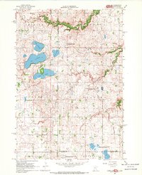
1967 Map of Canby NW
USGS Topo · Published 1969About this map
The rugged prairie borderlands of Yellow Medicine and Lincoln counties meet the South Dakota line in this 1967 survey. The landscape is defined by its glacial hydrology, with numerous basins such as Lake Cochrane, Lake Oliver, and Culver Lake forming a chain across the northwest. While the land is largely organized by the townships of Herrick, Florida, Norden, Fortier, Scandinavia, and Hansonville, much of the terrain is dedicated to conservation. A high concentration of managed lands, including the National Wildlife Management Area and the Penthole State Wildlife Management Area, suggests a region where natural drainage and waterfowl habitat take precedence over intensive cultivation. Rural infrastructure is sparse but specific, noted by a Townhall in the east and School No 114 near Cobb Creek. The presence of several Gravel Pits reflects the local glacial deposits used for building the grid of section roads that crisscross the plains.
Find a feature on this map
27 named features on this map. Tap any name to fly to it.
Don’t see what you’re looking for? This feature index may not catch every label — zoom into the map to look around manually.
Map Details
Editions of this 1967 Canby NW Map
2 editions found
Other maps of this area

1953 · Watertown
USGS Topo · 1:250,000

1958 · Watertown
USGS Topo · 1:250,000

1967 · Canby
USGS Topo · 1:24,000

1967 · Gary
USGS Topo · 1:24,000

1967 · Canby NW
USGS Topo · 1:24,000

1967 · Gary SE
USGS Topo · 1:24,000

1967 · Canby SE
USGS Topo · 1:24,000

1967 · Hendricks
USGS Topo · 1:24,000

1970 · Brandt
USGS Topo · 1:24,000

1970 · Astoria
USGS Topo · 1:24,000
Featured Places
- Norden Township, SD
- Herrick Township, SD
- Scandinavia Township, SD
- Yellow Medicine County, MN
- Lincoln County, MN