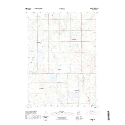
2019 Map of Canby SE
USGS Topo · Published 2019About this map
The Coteau des Prairies, a vast highland plateau, shapes the hydrology and agricultural layout of this Lincoln County landscape. This 2019 survey captures a region where natural water bodies and engineered drainage systems coexist, as seen in the headwaters of the Lac qui Parle River and the N Br Yellow Medicine River. The map highlights the transition of the land through labels like Bukowski Lakebed and Swenson Lakebed, indicating basins that no longer hold permanent open water. Local history is anchored by the Marble Cem, which sits along a grid of section roads like Co RD 20 and 370th ST. Significant engineering works, including Judicial Ditch Number Twentyone and Judicial Ditch Number Nineteen, illustrate the extensive efforts to manage the wetlands of the Coteau for regional cultivation.
Find a feature on this map
26 named features on this map. Tap any name to fly to it.
Don’t see what you’re looking for? This feature index may not catch every label — zoom into the map to look around manually.
Map Details
Editions of this 2019 Canby SE Map
This is the sole edition of this map. No revisions or reprints were ever made.
Other maps of this area

1953 · Watertown
USGS Topo · 1:250,000

1958 · Watertown
USGS Topo · 1:250,000

1963 · Arco
USGS Topo · 1:24,000

1967 · Canby
USGS Topo · 1:24,000

1967 · Canby NW
USGS Topo · 1:24,000

1967 · Porter
USGS Topo · 1:24,000
1967 · Porter SW
USGS Topo · 1:24,000

1967 · Lake Benton NW
USGS Topo · 1:24,000

1967 · Canby SE
USGS Topo · 1:24,000

1967 · Hendricks
USGS Topo · 1:24,000