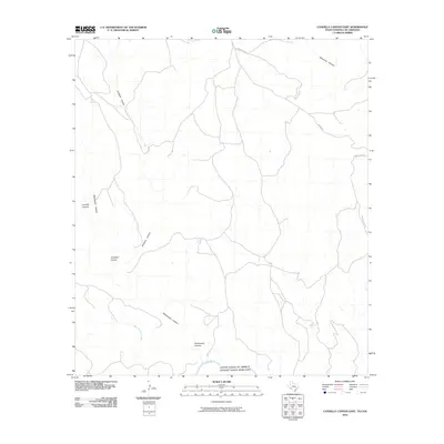
2010 Map of Candilla Canyon East
USGS Topo · Published 2010About this map
The Rio Grande serves as the prominent boundary between the United States and Mexico in this southwestern borderlands survey. The landscape is defined by a series of dramatic drainages that cut through the arid terrain, most notably Candilla Canyon and Washboard Canyon. These natural corridors reveal the complex topography of the region, where Son Francisco Creek flows toward the international border. Human presence is sparse, marked primarily by a network of ranch roads such as Gatlin Rd and Lower Gatlin Rd which navigate the heights above Seminole Canyon. This map provides a clear view of the geographic isolation and physical obstacles along the river at the start of the 21st century, where Isinglass Canyon wind through the hills.
Find a feature on this map
9 named features on this map. Tap any name to fly to it.
Don’t see what you’re looking for? This feature index may not catch every label — zoom into the map to look around manually.
Map Details
Editions of this 2010 Candilla Canyon East Map
This is the sole edition of this map. No revisions or reprints were ever made.
Other maps of this area

1918 · Dryden Crossing
USGS Topo · 1:62,500

1918 · Indian Wells
USGS Topo · 1:62,500

1928 · Sanderson
USGS Topo · 1:125,000

1954 · Fort Stockton
USGS Topo · 1:250,000

1958 · Fort Stockton
USGS Topo · 1:250,000

1959 · Emory Peak
USGS Topo · 1:250,000

1965 · Emory Peak
USGS Topo · 1:250,000

1969 · Sanderson SE
USGS Topo · 1:24,000

1969 · Mofeta
USGS Topo · 1:24,000
1969 · Hagler Canyon
USGS Topo · 1:24,000