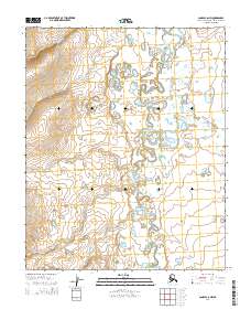
2014 Map of Candle C-6 NW
USGS Topo · Published 2014About this map
The Kiwalik River meanders across this portion of the Seward Peninsula, defining a landscape where numerous waterways converge. The presence of drainages with names like Gold Run and Bonanza Cr points to the region's historical associations with mineral prospecting and early twentieth-century exploration. These watercourses, including Eldorado Cr and Glacier Cr, are deeply etched into the terrain, reflecting the drainage patterns that have historically guided movement through this remote Alaskan interior. The map illustrates a transitional environment where the river system dominates the lowland topography, set against the backdrop of the surrounding uplands within the townships of t4n r16w and t3n r15w.
Find a feature on this map
14 named features on this map. Tap any name to fly to it.
Don’t see what you’re looking for? This feature index may not catch every label — zoom into the map to look around manually.
Map Details
Editions of this 2014 Candle C-6 NW Map
This is the sole edition of this map. No revisions or reprints were ever made.
Other maps of this area

1950 · Bendeleben C-1
USGS Topo · 1:63,360

1950 · Bendeleben
USGS Topo · 1:250,000

1950 · Bendeleben D-1
USGS Topo · 1:63,360

1950 · Candle C-6
USGS Topo · 1:63,360

1951 · Candle
USGS Topo · 1:250,000

1951 · Bendeleben
USGS Topo · 1:250,000

1951 · Candle D-6
USGS Topo · 1:63,360

1955 · Candle
USGS Topo · 1:250,000

1964 · Bendeleben
USGS Topo · 1:250,000

1964 · Candle
USGS Topo · 1:250,000