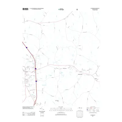
2013 Map of Candor
USGS Topo · Published 2013About this map
Candor serves as a primary hub of settlement in this 2013 survey of Montgomery County, defined by a grid of streets including North Main St and West Railroad St that reflect the area's transportation-driven development. The landscape is dotted with several significant water bodies and reservoirs, such as the Candor City Reservoir, Upper Pompelli Lake, and Ewing Lake, which suggest a managed approach to the local watershed. To the east, the small communities of Samarcand and Eagle Springs are connected by a network of rural roads that bypass large areas of timber and drainage basins like Drowning Creek. Notable landmarks include the Center Baptist Church and the extensive grounds of the Samarcand Manor State Correctional Instituti, which occupy a significant portion of the southern terrain.
Find a feature on this map
118 named features on this map. Tap any name to fly to it.
Don’t see what you’re looking for? This feature index may not catch every label — zoom into the map to look around manually.
Map Details
Editions of this 2013 Candor Map
This is the sole edition of this map. No revisions or reprints were ever made.
Other maps of this area

1942 · Troy
USGS Topo · 1:125,000

1949 · West End
USGS Topo · 1:24,000

1949 · Jackson Springs
USGS Topo · 1:62,500

1950 · Norman
USGS Topo · 1:24,000

1953 · Raleigh
USGS Topo · 1:250,000

1954 · Raleigh
USGS Topo · 1:250,000

1956 · Harrisville
USGS Topo · 1:24,000

1957 · Troy
USGS Topo · 1:62,500
1957 · Jackson Springs
USGS Topo · 1:62,500

1974 · Candor
USGS Topo · 1:24,000