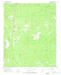
1964 Map of Cane Creek
USGS Topo · Published 1975About this map
Hurricane Creek and its many tributaries, such as Rosin Branch and George Creek, dominate this central Arkansas landscape at the border of Saline and Grant counties. The map reflects a mid-20th-century rural economy where small settlements like Cane Creek and Orion served as local hubs. Scattered churches and burial grounds, including Bethel Ch and the Jackson Cem, indicate established family communities. A notable transition in land use is visible with the presence of the Flying-D Ranch Landing Strip and several Gravel Pits, suggesting a shift toward more specialized agriculture and resource extraction. The northern boundary is marked by a prominent Lookout Tower and Roadside Park, while the network of unimproved roads and fence lines illustrates the intricate subdivision of the surrounding Banner and Simpson townships.
Find a feature on this map
46 named features on this map. Tap any name to fly to it.
Don’t see what you’re looking for? This feature index may not catch every label — zoom into the map to look around manually.
Map Details
Editions of this 1964 Cane Creek Map
4 editions found

Other maps of this area

1891 · Little Rock
USGS Topo · 1:125,000

1893 · Little Rock
USGS Topo · 1:125,000

1932 · Pastoria
USGS Topo · 1:62,500

1935 · Alexander
USGS Topo · 1:48,000

1935 · Pastoria
USGS Topo · 1:62,500

1940 · Woodson
USGS Topo · 1:31,680

1941 · Alexander
USGS Topo · 1:62,500

1944 · Spring Lake
USGS Topo · 1:31,680

1944 · Bryant
USGS Topo · 1:31,680
1954 · Woodson
USGS Topo · 1:24,000