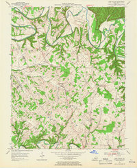
1953 Map of Cane Valley
USGS Topo · Published 1965About this map
Green River and Russell Creek define the winding geography of this central Kentucky landscape, where the border between Taylor and Adair counties meanders through deep bends and ridges. The settlement of Cane Valley serves as a central hub, surrounded by a dense network of family cemeteries and rural schoolhouses that speak to a closely-knit agricultural community in the early 1950s. Noteworthy landmarks include the Green River Hill Confederate Cemetery near Romine, and the subterranean feature of Saltpeter Cave located along the river bluffs. The land is marked by numerous small branches like Caney Fork and Dry Fork, which historically dictated the placement of homesteads and small crossroads communities such as Kellyville and Coburg. The distribution of institutions like St Elizabeth School and Mt Pleasant School & Cemetery illustrates a landscape where civic and spiritual life remained deeply decentralized.
Find a feature on this map
74 named features on this map. Tap any name to fly to it.
Don’t see what you’re looking for? This feature index may not catch every label — zoom into the map to look around manually.
Map Details
Editions of this 1953 Cane Valley Map
2 editions found
Other maps of this area

1952 · Mannsville
USGS Topo · 1:24,000

1953 · Gradyville
USGS Topo · 1:24,000

1953 · Campbellsville
USGS Topo · 1:24,000

1953 · Montpelier
USGS Topo · 1:24,000

1953 · Gresham
USGS Topo · 1:24,000

1953 · Cane Valley
USGS Topo · 1:24,000

1954 · Knifley
USGS Topo · 1:24,000

1954 · Columbia
USGS Topo · 1:24,000

1954 · Greensburg
USGS Topo · 1:24,000

1957 · Winchester
USGS Topo · 1:250,000