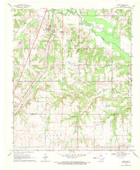
1969 Map of Caney
USGS Topo · Published 1971About this map
The settlement of Caney serves as a primary hub for this portion of southern Oklahoma, situated where the Missouri-Kansas-Texas railroad cuts across the prairie landscape. The area is defined by a series of waterways, most notably the winding course of Clear Boggy Creek and its tributaries like Davis Creek and Cowpen Creek. These drainage patterns shaped the early ranching and agricultural footprints evident on the map, including the expansive Stuart Ranch and its dedicated Stuart Ranch Landing Field.
Find a feature on this map
22 named features on this map. Tap any name to fly to it.
Don’t see what you’re looking for? This feature index may not catch every label — zoom into the map to look around manually.
Map Details
Editions of this 1969 Caney Map
This is the sole edition of this map. No revisions or reprints were ever made.
Other maps of this area

1899 · Atoka
USGS Topo · 1:125,000

1900 · Atoka
USGS Topo · 1:125,000

1957 · Bruno
USGS Topo · 1:24,000

1957 · Ardmore
USGS Topo · 1:250,000

1963 · Ardmore
USGS Topo · 1:250,000
1969 · Boggy Depot
USGS Topo · 1:24,000

1969 · Caddo North
USGS Topo · 1:24,000

1969 · Bokchito
USGS Topo · 1:24,000
1969 · Caddo South
USGS Topo · 1:24,000
1969 · Tushka
USGS Topo · 1:24,000