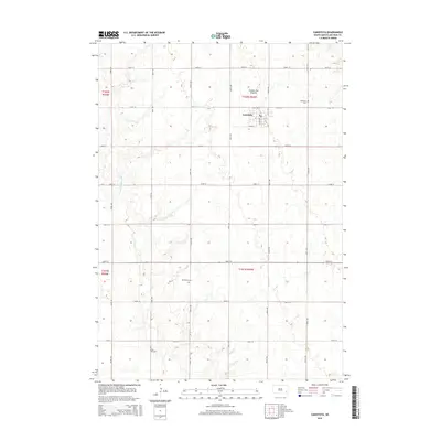
2015 Map of Canistota
USGS Topo · Published 2015About this map
Canistota serves as the primary hub on this McCook County landscape, situated where the high ground of the Coteau des Prairies begins to influence the local topography. This 2015 survey illustrates a rural South Dakota environment defined by a rigid section-line road grid, including 444th Ave and 265th St, which connects disparate farmsteads and agricultural plots. The western portion of the quadrangle is marked by the meandering path of the W Fork Vermillion River, providing a natural break in the geometric regularity of the prairie. For those documenting local families or land use, the map identifies several key burial sites including Canistota Cem just outside the town limits, Riverside Cem, and Rose Hill Cem to the south. The transition from the alluvial valley floor to the upland plateau is visible through subtle elevation changes, showing how the physical environment dictated the development of the region's transport and settlement patterns.
Find a feature on this map
28 named features on this map. Tap any name to fly to it.
Don’t see what you’re looking for? This feature index may not catch every label — zoom into the map to look around manually.
Map Details
Editions of this 2015 Canistota Map
This is the sole edition of this map. No revisions or reprints were ever made.
Other maps of this area

1898 · Parker
USGS Topo · 1:125,000

1955 · Sioux Falls
USGS Topo · 1:250,000

1958 · Sioux Falls
USGS Topo · 1:250,000

1964 · Montrose
USGS Topo · 1:24,000

1964 · Canistota
USGS Topo · 1:24,000

1964 · Salem NE
USGS Topo · 1:24,000

1964 · Salem
USGS Topo · 1:24,000

1964 · Bridgewater East
USGS Topo · 1:24,000

1964 · East Vermillion Lake
USGS Topo · 1:24,000
1968 · Parker
USGS Topo · 1:24,000