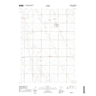
2017 Map of Canistota
USGS Topo · Published 2017About this map
Canistota stands as the primary hub of this eastern South Dakota landscape, situated within the distinctive Coteau des Prairies upland region. The town's grid is clearly defined by local thoroughfares such as Main St and Railway Ave, reflecting its historical development along the rail corridor. Beyond the residential center, the survey documents the winding path of the W Fork Vermillion River as it traverses the agricultural sections. For those researching local family history, the map precisely locates three distinct burial grounds: Canistota Cem on the town's eastern edge, Riverside Cem near the river, and Rose Hill Cem further south. The land is organized by a strict network of section-line roads, including Co Hwy 9 and numerous numbered avenues, which illustrate the enduring influence of the Public Land Survey System on the region's contemporary geography.
Find a feature on this map
33 named features on this map. Tap any name to fly to it.
Don’t see what you’re looking for? This feature index may not catch every label — zoom into the map to look around manually.
Map Details
Editions of this 2017 Canistota Map
This is the sole edition of this map. No revisions or reprints were ever made.
Other maps of this area

1898 · Parker
USGS Topo · 1:125,000

1955 · Sioux Falls
USGS Topo · 1:250,000

1958 · Sioux Falls
USGS Topo · 1:250,000

1964 · Montrose
USGS Topo · 1:24,000

1964 · Canistota
USGS Topo · 1:24,000

1964 · Salem NE
USGS Topo · 1:24,000

1964 · Salem
USGS Topo · 1:24,000

1964 · Bridgewater East
USGS Topo · 1:24,000

1964 · East Vermillion Lake
USGS Topo · 1:24,000
1968 · Parker
USGS Topo · 1:24,000