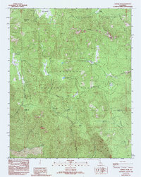
1986 Map of Cannell Peak
USGS Topo · Published 1994About this map
Sequoia National Forest encompasses this high-elevation landscape in the mid-1980s, where the rugged granitic terrain is defined by a network of meadows and seasonal drainages. The Dome Land Wilderness occupies the northeastern portion of the sheet, featuring prominent geological landmarks such as Church Dome and the heights of Cannell Peak. This environment supported a specialized forest management infrastructure, evidenced by the Cannell Meadow Forest Service Sta and scattered locations like Potato Patch.
Find a feature on this map
24 named features on this map. Tap any name to fly to it.
Don’t see what you’re looking for? This feature index may not catch every label — zoom into the map to look around manually.
Map Details
Editions of this 1986 Cannell Peak Map
2 editions found
Other maps of this area

1905 · Fairview
USGS Topo · 1:24,000

1906 · Kernville
USGS Topo · 1:125,000

1908 · Kernville
USGS Topo · 1:125,000

1918 · Fairview
USGS Topo · 1:31,680

1943 · Onyx
USGS Topo · 1:62,500

1943 · Isabella
USGS Topo · 1:62,500

1948 · Bakersfield
USGS Topo · 1:250,000

1955 · Bakersfield
USGS Topo · 1:250,000

1956 · Bakersfield
USGS Topo · 1:250,000
1956 · Kernville
USGS Topo · 1:62,500