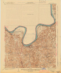
1934 Map of Cannelton
USGS Topo · Published 1941About this map
Cloverport and Hawesville anchor this reach of the Ohio River during the late 1920s and early 1930s, showing a landscape defined by the serpentine river and its numerous tributaries. The Louisville and Nashville railroad tracks follow the Kentucky shoreline, connecting riverfront landings and settlements like Addison and Stephensport. Inland, the map reveals a dense network of small rural communities and family landmarks, with prominent features such as Jeffrey Cliff and Persimmon Flat breaking the terrain.
Find a feature on this map
59 named features on this map. Tap any name to fly to it.
Don’t see what you’re looking for? This feature index may not catch every label — zoom into the map to look around manually.
Map Details
Editions of this 1934 Cannelton Map
2 editions found
Other maps of this area

1900 · St Meinrad
USGS Topo · 1:62,500

1903 · St. Meinrad
USGS Topo · 1:62,500

1903 · Tell City
USGS Topo · 1:62,500

1907 · Whitesville
USGS Topo · 1:62,500

1909 · Whitesville
USGS Topo · 1:62,500

1928 · Hardinsburg
USGS Topo · 1:48,000

1931 · Hardinsburg
USGS Topo · 1:62,500

1932 · Fordsville
USGS Topo · 1:62,500

1934 · Cannelton
USGS Topo · 1:62,500

1947 · Lodiburg
USGS Topo · 1:24,000