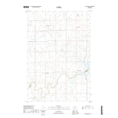
2018 Map of Cannon Ball NW
USGS Topo · Published 2018About this map
The Cannonball River winds through the southern reaches of this landscape, forming a natural boundary along the Morton Co Sioux Co line. This 2018 survey captures a terrain defined by extensive drainage systems, where the main course of Cantapeta Creek and its tributaries, including N Br Cantapeta Cr and Northwest Br Cantapeta Cr, carve out the prairie. In the northeast, the isolated landmark of Castle Butte rises above the surrounding contours, serving as a distinct topographical marker in an area otherwise characterized by soft draws and wide alluvial flats. The southeastern corner of the quadrangle is influenced by the waters of Lake Oahe, illustrating the reach of this reservoir into the river valley. A sparse network of roads, such as Co RD 80 and 15th Ave, provides the primary access across the sectional grid of the Cannonball District.
Find a feature on this map
18 named features on this map. Tap any name to fly to it.
Don’t see what you’re looking for? This feature index may not catch every label — zoom into the map to look around manually.
Map Details
Editions of this 2018 Cannon Ball NW Map
This is the sole edition of this map. No revisions or reprints were ever made.
Other maps of this area

1907 · Bismarck
USGS Topo · 1:125,000

1954 · Bismarck
USGS Topo · 1:250,000

1958 · Bismarck
USGS Topo · 1:250,000

1968 · Cannon Ball
USGS Topo · 1:24,000

1968 · Cannon Ball SE
USGS Topo · 1:24,000

1968 · Cannon Ball NW
USGS Topo · 1:24,000

1968 · Cannon Ball SW
USGS Topo · 1:24,000

1971 · Half Timber Butte
USGS Topo · 1:24,000

1971 · Huff
USGS Topo · 1:24,000

1971 · Fort Rice
USGS Topo · 1:24,000