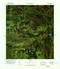
1977 Map of Cannon Corners Station
USGS Topo · Published 1978About this map
Canada United States border activity defines this 1970s orthophoto map, which provides a detailed look at the rural landscape surrounding the international boundary in Clinton County. The imagery shows a mosaic of dense forest and agricultural clearings, with the international line crossing through The Gulf and several remote access points. Key infrastructure including Covey Hill Canadian Customs and the Cannon Corners Station U S Customs illustrate the cross-border transit patterns of the era. To the north, the small settlements of Maritana, Stockwell, and Geraldine are visible amid the timber and farm plots. In the southern portion, the English River flows near Clinton Mills Road, while a network of woods paths such as the Blueberry Farm Trail and Degost Trail branch off from more established routes like Cannon Corners Road.
Find a feature on this map
22 named features on this map. Tap any name to fly to it.
Don’t see what you’re looking for? This feature index may not catch every label — zoom into the map to look around manually.
Map Details
Editions of this 1977 Cannon Corners Station Map
This is the sole edition of this map. No revisions or reprints were ever made.
Other maps of this area

1895 · Mooers
USGS Topo · 1:62,500

1899 · Mooers
USGS Topo · 1:62,500

1915 · Churubusco
USGS Topo · 1:62,500

1942 · Mooers
USGS Topo · 1:62,500

1943 · Churubusco
USGS Topo · 1:62,500

1943 · Mooers
USGS Topo · 1:62,500

1950 · Lake Champlain
USGS Topo · 1:250,000
1956 · Mooers
USGS Topo · 1:62,500

1958 · Lake Champlain
USGS Topo · 1:250,000

1962 · Lake Champlain
USGS Topo · 1:250,000