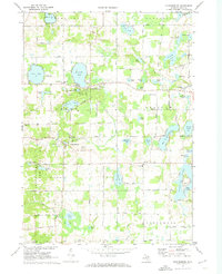
1972 Map of Cannonsburg
USGS Topo · Published 1974About this map
The unincorporated village of Cannonsburg serves as a focal point in this 1970s survey of northeastern Kent County, situated where the landscape transitions from the managed Cannon State Game Area to an undulating terrain of glacial kettle lakes. The area exhibits a classic post-war Michigan residential pattern, with seasonal and year-round communities established around bodies of water like Bostwick Lake and Silver Lake. Small agrarian and religious centers remain prominent, such as the hamlet of Parnell, defined by St Patricks Sch, and the cluster of community life at Grattan. Local history is anchored by numerous family and pioneer landmarks, including the Cannonsburg Cem and Cannon Cem, while the presence of the Silver Lake Country Club and several Gravel Pits reflects the area's dual role as a site for both recreation and resource extraction during this era.
Find a feature on this map
69 named features on this map. Tap any name to fly to it.
Don’t see what you’re looking for? This feature index may not catch every label — zoom into the map to look around manually.
Map Details
Editions of this 1972 Cannonsburg Map
This is the sole edition of this map. No revisions or reprints were ever made.
Other maps of this area

1914 · Grand Rapids
USGS Topo · 1:62,500

1918 · Cedar Springs
USGS Topo · 1:62,500

1918 · Lowell
USGS Topo · 1:62,500

1943 · Cedar Springs
USGS Topo · 1:62,500

1943 · Grand Rapids
USGS Topo · 1:62,500

1943 · Lowell
USGS Topo · 1:62,500

1954 · Midland
USGS Topo · 1:250,000

1958 · Midland
USGS Topo · 1:250,000

1958 · Grand Rapids
USGS Topo · 1:250,000

1959 · Midland
USGS Topo · 1:250,000