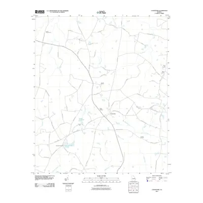
2011 Map of Canoochee
USGS Topo · Published 2011About this map
Canoochee lies at the heart of this Emanuel County landscape, situated where the Canoochee Byp and Canoochee Garfield Rd converge. This rural Georgia topography is defined by a dense network of watercourses, including the southward flow of Fifteenmile Creek and Little Canoochee Creek, which feed into local agricultural landmarks like Durden Farm Pond and Overstreet Lake. The map reveals a highly localized geography of family and community lineage, marked by a significant number of cemeteries including Bishops Chapel Cemetery, Sand Hill Cemetery, and Mount Gilead Cemetery.
Find a feature on this map
63 named features on this map. Tap any name to fly to it.
Don’t see what you’re looking for? This feature index may not catch every label — zoom into the map to look around manually.
Map Details
Editions of this 2011 Canoochee Map
This is the sole edition of this map. No revisions or reprints were ever made.
Other maps of this area

1957 · Macon
USGS Topo · 1:250,000

1958 · Macon
USGS Topo · 1:250,000

1964 · Macon
USGS Topo · 1:250,000

1971 · Swainsboro
USGS Topo · 1:24,000

1971 · Twin City
USGS Topo · 1:24,000
1971 · Twin City SE
USGS Topo · 1:24,000
1971 · Garfield
USGS Topo · 1:24,000
1971 · Canoochee
USGS Topo · 1:24,000

1971 · Summertown
USGS Topo · 1:24,000

1973 · Colemans Lake
USGS Topo · 1:24,000