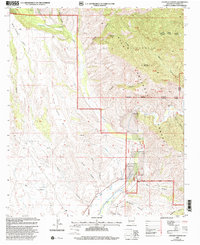
1999 Map of Canteen Canyon
USGS Topo · Published 2002About this map
Mogollon Creek and the Gila River define this complex landscape in Grant County, where deep drainages like Canteen Canyon and Miller Canyon cut through high plateaus. The map details the transition from the private 916 Ranch to the protected expanse of the Gila Wilderness and the Gila National Forest. Evidence of land management and resource use is scattered throughout the terrain, including a Gaging Station on the river, several Mine locations, and an Aqueduct system near the forest boundary.
Find a feature on this map
44 named features on this map. Tap any name to fly to it.
Don’t see what you’re looking for? This feature index may not catch every label — zoom into the map to look around manually.
Map Details
Editions of this 1999 Canteen Canyon Map
This is the sole edition of this map. No revisions or reprints were ever made.
Other maps of this area

1909 · Silver City
USGS Topo · 1:125,000

1910 · Mogollon
USGS Topo · 1:125,000

1911 · Alum Mountain
USGS Topo · 1:125,000

1912 · Mogollon
USGS Topo · 1:125,000

1913 · Alum Mountain
USGS Topo · 1:125,000

1950 · Dorsey Ranch
USGS Topo · 1:24,000

1951 · Dorsey Ranch
USGS Topo · 1:24,000

1954 · Silver City
USGS Topo · 1:250,000

1954 · Clifton
USGS Topo · 1:250,000

1957 · Clifton
USGS Topo · 1:250,000