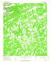
1961 Map of Canton
USGS Topo · Published 1963About this map
The Etowah River carves through the northern landscape of this Cherokee County region, anchoring the industrial and civic hub of Canton. During the early 1960s, the town's development was defined by the Louisville and Nashville railroad corridor and local infrastructure including the Waterworks, a Prison Camp, and Harmon Field. The surrounding countryside reveals a dense network of early communities and faith centers such as Hickory Flat, Carmichael Crossroads, and Indian Knoll Ch.
Find a feature on this map
50 named features on this map. Tap any name to fly to it.
Don’t see what you’re looking for? This feature index may not catch every label — zoom into the map to look around manually.
Map Details
Editions of this 1961 Canton Map
4 editions found
Other maps of this area

1890 · Suwanee
USGS Topo · 1:125,000

1890 · Cartersville
USGS Topo · 1:125,000

1891 · Cartersville
USGS Topo · 1:125,000

1894 · Suwanee
USGS Topo · 1:125,000

1896 · Cartersville
USGS Topo · 1:125,000

1907 · Acworth
USGS Topo · 1:62,500

1909 · Acworth
USGS Topo · 1:62,500

1926 · Tate
USGS Topo · 1:62,500

1928 · Tate
USGS Topo · 1:62,500

1947 · Waleska
USGS Topo · 1:62,500