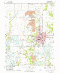
1974 Map of Canton
USGS Topo · Published 1978About this map
Canton serves as the industrial and civic heart of this Fulton County landscape, characterized by a complex balance of urban infrastructure and extensive extraction. To the north and west of the city center, the terrain is defined by large Strip Mine operations and a sprawling Strip Mined Area, creating a distinct topography of reclaimed land and water bodies like Van Winkle Lake. The city itself is a dense network of residential streets and essential institutions, including the Graham Hospital and numerous neighborhood schools such as McCall Sch and Wright Sch.
Find a feature on this map
66 named features on this map. Tap any name to fly to it.
Don’t see what you’re looking for? This feature index may not catch every label — zoom into the map to look around manually.
Map Details
Editions of this 1974 Canton Map
This is the sole edition of this map. No revisions or reprints were ever made.
Other maps of this area

1912 · Canton
USGS Topo · 1:62,500

1925 · Havana
USGS Topo · 1:62,500

1929 · Manito
USGS Topo · 1:62,500

1930 · Glasford
USGS Topo · 1:62,500

1932 · Manito
USGS Topo · 1:62,500

1947 · Lewistown
USGS Topo · 1:24,000

1947 · St. David
USGS Topo · 1:24,000

1948 · Lewistown
USGS Topo · 1:24,000

1948 · St. David
USGS Topo · 1:24,000

1948 · Glasford
USGS Topo · 1:62,500