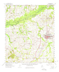
1961 Map of Canton
USGS Topo · Published 1975About this map
Canton serves as the focal point of this Madison County landscape, where the Illinois Central railroad corridor drives the local geography. The town plan is densely detailed, featuring the County Fairground, a Drive-in Theater, and the Rogers High Sch campus with its associated Rogers High Sch Cem. Surrounding the seat of government, the rural countryside is dotted with small communities like Gluckstadt, Livingston, and Annandale, each connected by a network of local roads and the developing Natchez Trace Parkway.
Find a feature on this map
117 named features on this map. Tap any name to fly to it.
Don’t see what you’re looking for? This feature index may not catch every label — zoom into the map to look around manually.
Map Details
Editions of this 1961 Canton Map

Other maps of this area

1903 · Jackson
USGS Topo · 1:125,000

1905 · Jackson
USGS Topo · 1:48,000

1908 · Jackson
USGS Topo · 1:62,500

1922 · Pelahatchee
USGS Topo · 1:48,000

1924 · Pelahatchee
USGS Topo · 1:62,500

1934 · Raymond
USGS Topo · 1:48,000

1937 · Raymond
USGS Topo · 1:62,500

1942 · Raymond
USGS Topo · 1:62,500

1950 · Pelahatchie
USGS Topo · 1:62,500

1952 · Pelahatchie
USGS Topo · 1:62,500