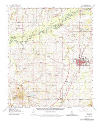
1961 Map of Canton
USGS Topo · Published 1987About this map
The Canton area in the early 1960s is defined by its strategic position along the Illinois Central Railroad, serving as a vital hub for Madison County. This survey reveals a landscape of concentrated town growth surrounded by dispersed rural settlements such as Livingston, Annandale, and Gluckstadt. The eastern edge of the map follows the intricate oxbows of the Black River, where features like Hendricks Lake and Deadman Lake highlight a complex riverine environment that shaped early transport and land use. Local life is anchored by numerous small spiritual and educational centers, including Campbell Chapel and Mt Zion Ch, as well as the Arbondale Sch and Madison High Sch. The presence of the County Fairground and a Drive-in Theater in the city's periphery illustrates the mid-century social character of this Mississippi county seat.
Find a feature on this map
113 named features on this map. Tap any name to fly to it.
Don’t see what you’re looking for? This feature index may not catch every label — zoom into the map to look around manually.
Map Details
Editions of this 1961 Canton Map

Other maps of this area

1903 · Jackson
USGS Topo · 1:125,000

1905 · Jackson
USGS Topo · 1:48,000

1908 · Jackson
USGS Topo · 1:62,500

1922 · Pelahatchee
USGS Topo · 1:48,000

1924 · Pelahatchee
USGS Topo · 1:62,500

1934 · Raymond
USGS Topo · 1:48,000

1937 · Raymond
USGS Topo · 1:62,500

1942 · Raymond
USGS Topo · 1:62,500

1950 · Pelahatchie
USGS Topo · 1:62,500

1952 · Pelahatchie
USGS Topo · 1:62,500