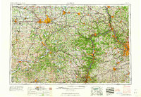
1962 Map of Canton
USGS Topo · Published 1962About this map
Canton and Pittsburgh anchor this mid-century look at the industrial heartland where the Allegheny Plateau meets the sprawling river valleys of the upper Ohio basin. The map illustrates a landscape defined by its heavy infrastructure, following the Ohio River as it winds through Steubenville and Wheeling. Regional connectivity is on full display through the dense networks of the Pennsylvania RR and the Baltimore & Ohio RR, alongside the emerging path of the Lincoln Highway.
Find a feature on this map
71 named features on this map. Tap any name to fly to it.
Don’t see what you’re looking for? This feature index may not catch every label — zoom into the map to look around manually.
Map Details
Editions of this 1962 Canton Map
2 editions found

Other maps of this area

1900 · Masontown
USGS Topo · 1:62,500

1901 · Cadiz
USGS Topo · 1:62,500

1901 · Massillon
USGS Topo · 1:62,500

1901 · Amity
USGS Topo · 1:62,500

1901 · Canton
USGS Topo · 1:62,500

1901 · Waynesburg
USGS Topo · 1:62,500

1901 · Beaver
USGS Topo · 1:62,500

1901 · Wooster
USGS Topo · 1:62,500

1902 · Wheeling
USGS Topo · 1:62,500

1902 · Brownsville
USGS Topo · 1:62,500