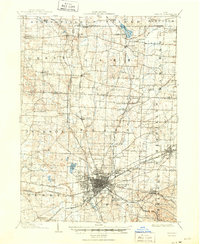
1903 Map of Canton
USGS Topo · Published 1950About this map
Canton serves as the industrial and transit hub of Stark County in this turn-of-the-century survey, shown as a dense grid of streets including Market Street and Tuscarawas Street. The city is a major junction for the Pennsylvania System and the Wheeling and Lake Erie R. R., highlighting the era's reliance on heavy rail to connect the various branches of the Nimishillen Creek. Outside the city center, the landscape is dotted with smaller agrarian settlements and specialized sites such as the Infirmary and Westlawn Cem.
Find a feature on this map
51 named features on this map. Tap any name to fly to it.
Don’t see what you’re looking for? This feature index may not catch every label — zoom into the map to look around manually.
Map Details
Editions of this 1903 Canton Map
2 editions found
Other maps of this area

1901 · Massillon
USGS Topo · 1:62,500

1901 · Canton
USGS Topo · 1:62,500

1903 · Massillon
USGS Topo · 1:62,500

1903 · Canton
USGS Topo · 1:62,500

1903 · Akron
USGS Topo · 1:62,500

1905 · Akron
USGS Topo · 1:62,500

1906 · Kent
USGS Topo · 1:62,500

1906 · Ravenna
USGS Topo · 1:62,500

1908 · Ravenna
USGS Topo · 1:62,500

1909 · Alliance
USGS Topo · 1:62,500