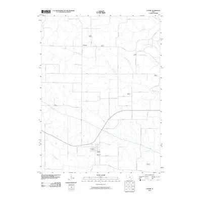
2010 Map of Cantril
USGS Topo · Published 2010About this map
The Fox River meanders across this rural Van Buren County landscape, defining the topography of the southern portion of the quadrangle near the settlement of Cantril. This area is characterized by its numerous small, family-named burial grounds, which offer significant value for genealogical research. Locations like Egypt Cemetery, Ten Sych Cemetery, and Mantoyne Cemetery are scattered throughout the township-and-range grid, often tucked away from the main thoroughfares. In the north, the small community of Lebanon sits along Co Hwy J40, surrounded by its namesake Lebanon Cemetery. The map detail captures the rural infrastructure of the early 21st century, from the Cantril Post Office to the network of gravel and paved roads like Gray Ave and Heather Ave that connect the isolated farmsteads and creek valleys of Big Indian Creek and its tributary, Tug Fork Big Indian Creek.
Find a feature on this map
49 named features on this map. Tap any name to fly to it.
Don’t see what you’re looking for? This feature index may not catch every label — zoom into the map to look around manually.
Map Details
Editions of this 2010 Cantril Map
This is the sole edition of this map. No revisions or reprints were ever made.
Other maps of this area

1954 · Centerville
USGS Topo · 1:250,000

1957 · Centerville
USGS Topo · 1:250,000

1958 · Centerville
USGS Topo · 1:250,000

1958 · Burlington
USGS Topo · 1:250,000

1961 · Burlington
USGS Topo · 1:250,000

1963 · Burlington
USGS Topo · 1:250,000

1965 · Selma
USGS Topo · 1:24,000

1965 · Douds
USGS Topo · 1:24,000

1968 · Keosauqua
USGS Topo · 1:24,000
1968 · Mount Sterling
USGS Topo · 1:24,000