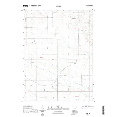
2018 Map of Cantril
USGS Topo · Published 2018About this map
Cantril anchors the southern portion of this Van Buren County landscape, situated just north of the Little Fox River. The terrain is defined by the winding paths of the Fox River and its numerous tributaries, including Big Indian Cr and Duckworth Cr, which carve through the agricultural uplands. To the north, the small settlement of Lebanon sits at a crossroads, surrounded by a dense network of country roads like Fir Ave and Rte J40. Family and community history is deeply rooted in the landscape, evidenced by a high concentration of small burial grounds. From the Maple Grove Cem near town to the more isolated Egypt Cem and Ten Sych Cem, these sites offer significant points of interest for genealogical research in a region largely defined by its rural character and river-bottom drainage patterns.
Find a feature on this map
64 named features on this map. Tap any name to fly to it.
Don’t see what you’re looking for? This feature index may not catch every label — zoom into the map to look around manually.
Map Details
Editions of this 2018 Cantril Map
This is the sole edition of this map. No revisions or reprints were ever made.
Other maps of this area

1954 · Centerville
USGS Topo · 1:250,000

1957 · Centerville
USGS Topo · 1:250,000

1958 · Centerville
USGS Topo · 1:250,000

1958 · Burlington
USGS Topo · 1:250,000

1961 · Burlington
USGS Topo · 1:250,000

1963 · Burlington
USGS Topo · 1:250,000

1965 · Selma
USGS Topo · 1:24,000

1965 · Douds
USGS Topo · 1:24,000

1968 · Keosauqua
USGS Topo · 1:24,000
1968 · Mount Sterling
USGS Topo · 1:24,000