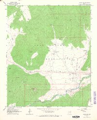
1966 Map of Canyon Day
USGS Topo · Published 1968About this map
Fort Apache Indian Reservation lands dominate this mid-1960s survey, defined by the winding course of the White River as it flows past the settlement of Canyon Day. The landscape is a mix of high plateau and deep canyons, marked by significant archaeological and historical landmarks like the Kinishba Ruins and the prominent Sevenmile Rim. This era of the reservation is recorded through its cattle-working infrastructure and water management, featuring numerous named tanks and wells such as Kinishba Well and Stockman Station. The survey captures the complex jurisdictional history of the area, clearly delineating the Old Indian School Boundary. Beyond the river valley, the terrain is characterized by distinctive formations including Sawtooth Mtn and Tsay-se-zhin Butte, while human activity is evidenced by scattered Gravel Pit sites and a Rifle Range.
Find a feature on this map
47 named features on this map. Tap any name to fly to it.
Don’t see what you’re looking for? This feature index may not catch every label — zoom into the map to look around manually.
Map Details
Editions of this 1966 Canyon Day Map
This is the sole edition of this map. No revisions or reprints were ever made.
Other maps of this area

1954 · Clifton
USGS Topo · 1:250,000

1954 · Mesa
USGS Topo · 1:250,000

1957 · Mesa
USGS Topo · 1:250,000

1957 · Clifton
USGS Topo · 1:250,000

1958 · Clifton
USGS Topo · 1:250,000

1958 · Mesa
USGS Topo · 1:250,000

1960 · Mesa
USGS Topo · 1:250,000

1962 · Clifton
USGS Topo · 1:250,000

1964 · Mesa
USGS Topo · 1:250,000
1966 · Forks Butte
USGS Topo · 1:24,000