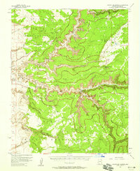
1955 Map of Canyon Del Muerto
USGS Topo · Published 1971About this map
Canyon De Chelly and its northern branch, Canyon Del Muerto, reveal a complex landscape of deep sandstone gorges and ancient habitation within the Navajo Indian Reservation. This mid-century survey documents the spatial relationship between numerous prehistoric cliff dwellings, such as Massacre Cave Ruins and Mummy Cave Ruins, and the contemporary presence of the Canyon Del Muerto School. The map serves as a detailed record of the Canyon De Chelly National Monument before the expansion of modern tourism infrastructure, when movement through the canyons relied heavily on the Jeep Trail network. Prominent landmarks like Spider Rock and Face Rock stand as sentinels over the canyon floor, while smaller drainages like Three Turkey Canyon show additional archaeological sites such as Three Turkey Ruins tucked away from the primary corridors.
Find a feature on this map
55 named features on this map. Tap any name to fly to it.
Don’t see what you’re looking for? This feature index may not catch every label — zoom into the map to look around manually.
Map Details
Editions of this 1955 Canyon Del Muerto Map
2 editions found
Other maps of this area

1886 · Fort Defiance
USGS Topo · 1:250,000

1892 · Fort Defiance
USGS Topo · 1:250,000

1892 · Canyon De Chelly
USGS Topo · 1:250,000

1954 · Shiprock
USGS Topo · 1:250,000

1954 · Gallup
USGS Topo · 1:250,000

1955 · Chinle 4 NE
USGS Topo · 1:24,000

1955 · Zith-Tusayan Butte 2 NW
USGS Topo · 1:24,000

1955 · Chinle 4 SE
USGS Topo · 1:24,000

1955 · Zith-Tusayan Butte 2 NE
USGS Topo · 1:24,000

1955 · Sonsala Butte 2 SW
USGS Topo · 1:24,000
Featured Places
- Chinle Agency, AZ
- Fort Defiance Agency
- Junction Overlook, Chinle Agency
- Del Muerto, Chinle Agency
- Apache County, AZ