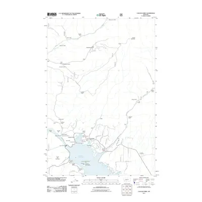
2011 Map of Canyon Ferry
USGS Topo · Published 2011About this map
Canyon Ferry Lake dominates this Montana landscape, where the waters of the Missouri River are held back by the Canyon Ferry Dam. The settlement of Canyon Ferry sits at the northern end of the reservoir, flanked by a complex network of gulches and hills including Goon Hill and Cemetery Hill. The terrain north and east of the lake is marked by numerous seasonal drainage features such as Washout Gulch, Big Rattlesnake Gulch, and Browns Gulch, illustrating the high-relief topography rising toward Hedges Mountain.
Find a feature on this map
78 named features on this map. Tap any name to fly to it.
Don’t see what you’re looking for? This feature index may not catch every label — zoom into the map to look around manually.
Map Details
Editions of this 2011 Canyon Ferry Map
This is the sole edition of this map. No revisions or reprints were ever made.
Other maps of this area

1886 · Fort Logan
USGS Topo · 1:250,000

1948 · White Sulphur Springs
USGS Topo · 1:250,000

1950 · Canyon Ferry
USGS Topo · 1:62,500

1950 · East Helena
USGS Topo · 1:62,500

1958 · White Sulphur Springs
USGS Topo · 1:250,000

1961 · White Sulphur Springs
USGS Topo · 1:250,000

1962 · Hogback Mountain
USGS Topo · 1:24,000
1962 · Nelson
USGS Topo · 1:24,000

1962 · Snedaker Basin
USGS Topo · 1:24,000

1965 · White Sulphur Springs
USGS Topo · 1:250,000