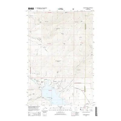
2014 Map of Canyon Ferry
USGS Topo · Published 2014About this map
Canyon Ferry Lake and Hauser Lake dominate this landscape, reflecting the engineering of the Missouri River as it flows through the Big Belt Mountains. The settlement of Canyon Ferry and the smaller enclave at Cavetown serve as focal points for the region's mid-century water management and recreation. Of significant interest to genealogists and local historians is the Cem Island / Canyon Ferry Cemetery, a poignant reminder of the landscape prior to the inundation of the valley.
Find a feature on this map
77 named features on this map. Tap any name to fly to it.
Don’t see what you’re looking for? This feature index may not catch every label — zoom into the map to look around manually.
Map Details
Editions of this 2014 Canyon Ferry Map
This is the sole edition of this map. No revisions or reprints were ever made.
Other maps of this area

1886 · Fort Logan
USGS Topo · 1:250,000

1948 · White Sulphur Springs
USGS Topo · 1:250,000

1950 · Canyon Ferry
USGS Topo · 1:62,500

1950 · East Helena
USGS Topo · 1:62,500

1958 · White Sulphur Springs
USGS Topo · 1:250,000

1961 · White Sulphur Springs
USGS Topo · 1:250,000

1962 · Hogback Mountain
USGS Topo · 1:24,000
1962 · Nelson
USGS Topo · 1:24,000

1962 · Snedaker Basin
USGS Topo · 1:24,000

1965 · White Sulphur Springs
USGS Topo · 1:250,000