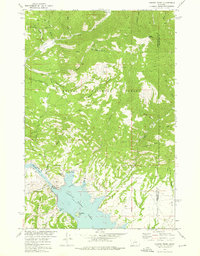
1972 Map of Canyon Ferry
USGS Topo · Published 1976About this map
The Missouri River dominates this landscape as it transitions into Canyon Ferry Lake and Hauser Lake, regulated by the massive infrastructure of the Canyon Ferry Dam and its associated Powerplant. In the northern uplands, the small settlement of York serves as a gateway to a terrain defined by deep gulches and a legacy of hard-rock mining. Traces of industrial history are etched into the hillsides at the Golden Messenger Mine, Little Dandy Mine, and Korizek Mine, while numerous unnamed Prospects dot the drainages of Trout Creek and Oregon Gulch.
Find a feature on this map
59 named features on this map. Tap any name to fly to it.
Don’t see what you’re looking for? This feature index may not catch every label — zoom into the map to look around manually.
Map Details
Editions of this 1972 Canyon Ferry Map
2 editions found
Other maps of this area

1886 · Fort Logan
USGS Topo · 1:250,000

1948 · White Sulphur Springs
USGS Topo · 1:250,000

1950 · Canyon Ferry
USGS Topo · 1:62,500

1950 · East Helena
USGS Topo · 1:62,500

1958 · White Sulphur Springs
USGS Topo · 1:250,000

1961 · White Sulphur Springs
USGS Topo · 1:250,000

1962 · Hogback Mountain
USGS Topo · 1:24,000
1962 · Nelson
USGS Topo · 1:24,000

1962 · Snedaker Basin
USGS Topo · 1:24,000

1965 · White Sulphur Springs
USGS Topo · 1:250,000