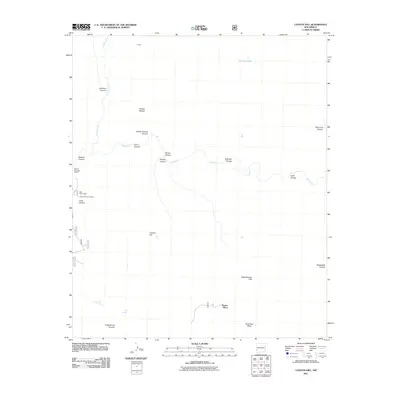
2011 Map of Canyon Hill
USGS Topo · Published 2011About this map
Rastus Place sits as a quiet landmark in this high-desert landscape, where the Gila River carves a winding path through a series of named canyons and rocky overlooks. This 2011 survey illustrates the geological complexity of the area, featuring mineral interests like the Blue Benny Mine, the Brock Canyon Prospect, and the Watson Mountain Deposit. These sites highlight a history of exploration for resources within the rugged breaks of the river valley. Water sources are critical points of reference here, ranging from the seasonal The Dry Lakes in the north to reliable points like Cottonwood Spring and Dog Spring in the south. The topography is defined by prominent elevations such as Canyon Hill and the broad Slick Rock Mesa, while the drainage network includes the deep incisions of Turkey Creek and Skeleton Canyon. This map serves as a contemporary record of the land's form, preserved just as it was in the early 21st century.
Find a feature on this map
26 named features on this map. Tap any name to fly to it.
Don’t see what you’re looking for? This feature index may not catch every label — zoom into the map to look around manually.
Map Details
Editions of this 2011 Canyon Hill Map
This is the sole edition of this map. No revisions or reprints were ever made.
Other maps of this area

1909 · Silver City
USGS Topo · 1:125,000

1910 · Mogollon
USGS Topo · 1:125,000

1911 · Alum Mountain
USGS Topo · 1:125,000

1912 · Mogollon
USGS Topo · 1:125,000

1913 · Alum Mountain
USGS Topo · 1:125,000

1950 · Dorsey Ranch
USGS Topo · 1:24,000

1950 · Reading Mountain
USGS Topo · 1:24,000

1951 · Dorsey Ranch
USGS Topo · 1:24,000
1952 · Reading Mountain
USGS Topo · 1:24,000

1954 · Silver City
USGS Topo · 1:250,000