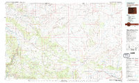
1979 Map of Canyon of Lodore
USGS Topo · Published 1979About this map
The Canyon of Lodore carves through the northwestern corner of Colorado, defining a landscape where the Green River meets the high desert plateaus. In this late 1970s survey, the remote character of Moffat County is evident through the expansive boundaries of Dinosaur National Monument and the Browns Park National Wildlife Refuge. The map details a complex drainage system where Vermillion Creek and the Little Snake River feed toward the Yampa River near Maybell.
Find a feature on this map
117 named features on this map. Tap any name to fly to it.
Don’t see what you’re looking for? This feature index may not catch every label — zoom into the map to look around manually.
Map Details
Editions of this 1979 Canyon of Lodore Map
2 editions found
Other maps of this area

1885 · Ashley
USGS Topo · 1:250,000

1907 · Rangely
USGS Topo · 1:125,000

1907 · Jensen
USGS Topo · 1:125,000

1907 · White River
USGS Topo · 1:125,000

1910 · Danforth Hills
USGS Topo · 1:125,000

1910 · Jensen
USGS Topo · 1:125,000

1910 · White River
USGS Topo · 1:125,000

1910 · Rangely
USGS Topo · 1:125,000

1912 · Axial
USGS Topo · 1:62,500

1914 · Axial
USGS Topo · 1:62,500