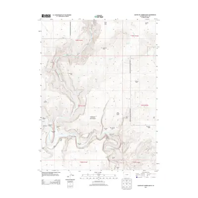
2013 Map of Canyon of Lodore South
USGS Topo · Published 2013About this map
Dinosaur National Monument encompasses the heart of this landscape, where the confluence of the Green River and the Yampa River takes place at Echo Park. This 2013 survey illustrates a wilderness defined by dramatic geological formations and river navigation hazards, including the Canyon of Lodore and the Half Mile Rapid. The map documents remote human outposts like Massey Cabin and Gardners Cabin, which stand against a backdrop of steep drainages such as Burnt Gulch and Iron Mine Draw. To the south, Steamboat Rock and Jenny Lind Rock serve as massive landmarks for those navigating the canyons. The topography transitions from high points like Wild Mountain to the sheer drops of Warms Spring Cliff, while the southern reaches reveal features like Outlaw Arch and the isolated Outlaw Park. The presence of Starvation Valley and Zenobia Basin underscores the formidable and remote character of this northwestern Colorado terrain.
Find a feature on this map
44 named features on this map. Tap any name to fly to it.
Don’t see what you’re looking for? This feature index may not catch every label — zoom into the map to look around manually.
Map Details
Editions of this 2013 Canyon of Lodore South Map
This is the sole edition of this map. No revisions or reprints were ever made.
Other maps of this area

1885 · Ashley
USGS Topo · 1:250,000

1907 · Rangely
USGS Topo · 1:125,000

1907 · Jensen
USGS Topo · 1:125,000

1910 · Jensen
USGS Topo · 1:125,000

1910 · Rangely
USGS Topo · 1:125,000

1954 · Hells Canyon
USGS Topo · 1:24,000

1954 · Canyon of Lodore South
USGS Topo · 1:24,000

1954 · Canyon of Lodore North
USGS Topo · 1:24,000

1954 · Vernal
USGS Topo · 1:250,000

1955 · Stuntz Reservoir
USGS Topo · 1:24,000