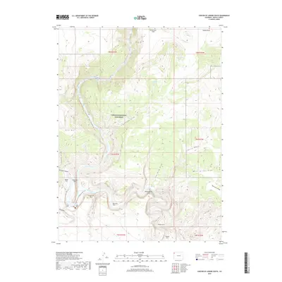
2019 Map of Canyon of Lodore South
USGS Topo · Published 2019About this map
Dinosaur National Monument encompasses a dramatic convergence of water and stone within this northern Colorado landscape. The deep incision of the Canyon of Lodore follows the Green River southward until it meets the Yampa River at Echo Park. This confluence is marked by massive geologic features like Steamboat Rock and Jenny Lind Rock, which rise sharply from the riverbanks. High plateaus such as the Zenobia Basin and the Green River Slope overlook the canyons, while hidden alcoves and springs like Chokecherry Spring dot the arid terrain. The map details the complex drainage systems of Burnt Gulch and Iron Mine Draw, illustrating the rugged topography that historically dictated travel and settlement in this corner of Moffat County. Modern access is preserved through the Confluence/Sand Canyon Access Trail, linking the lower parks to the surrounding canyon walls.
Find a feature on this map
39 named features on this map. Tap any name to fly to it.
Don’t see what you’re looking for? This feature index may not catch every label — zoom into the map to look around manually.
Map Details
Editions of this 2019 Canyon of Lodore South Map
This is the sole edition of this map. No revisions or reprints were ever made.
Other maps of this area

1885 · Ashley
USGS Topo · 1:250,000

1907 · Rangely
USGS Topo · 1:125,000

1907 · Jensen
USGS Topo · 1:125,000

1910 · Jensen
USGS Topo · 1:125,000

1910 · Rangely
USGS Topo · 1:125,000

1954 · Hells Canyon
USGS Topo · 1:24,000

1954 · Canyon of Lodore South
USGS Topo · 1:24,000

1954 · Canyon of Lodore North
USGS Topo · 1:24,000

1954 · Vernal
USGS Topo · 1:250,000

1955 · Stuntz Reservoir
USGS Topo · 1:24,000