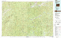
1989 Map of Canyonville
USGS Topo · Published 1989About this map
Wolf Creek and Sunny Valley anchor the southern corridor of this late-twentieth-century study of Southern Oregon's transition from the Umpqua to the Rogue River drainages. The Southern Pacific railroad and Interstate 5 parallel each other through the mountainous terrain, linking settlements like Glendale and Leland. This infrastructure supports a landscape historically defined by extraction, evidenced by numerous legacy mining operations such as the Greenback Mine, Silver Peak Mine, and Almeda Mine. In the southwest, the Rogue River National Wild and Scenic River carves through the Siskiyou National Forest, while the northern reaches include the community of Riddle and the Umpqua River. The map meticulously details the intersection of rugged wilderness boundaries, including the Kalmiopsis Wilderness, with the industrial footprints of the Canyon Mountain Mine and Granite Hill Mine.
Find a feature on this map
119 named features on this map. Tap any name to fly to it.
Don’t see what you’re looking for? This feature index may not catch every label — zoom into the map to look around manually.
Map Details
Editions of this 1989 Canyonville Map
2 editions found
Other maps of this area

1891 · Ashland
USGS Topo · 1:250,000

1893 · Ashland
USGS Topo · 1:250,000

1896 · Coos Bay
USGS Topo · 1:125,000

1897 · Roseburg
USGS Topo · 1:125,000

1897 · Ashland
USGS Topo · 1:250,000

1898 · Coos Bay
USGS Topo · 1:125,000

1899 · Port Orford
USGS Topo · 1:125,000

1900 · Roseburg
USGS Topo · 1:125,000

1900 · Coos Bay
USGS Topo · 1:125,000

1903 · Port Orford
USGS Topo · 1:125,000