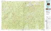
1989 Map of Canyonville
USGS Topo · Published 1989About this map
Interstate 5 and the Southern Pacific Railroad provide the primary north-south corridors through this southwestern Oregon landscape, threading between steep ridges and narrow river valleys. The map documents the late-twentieth-century development of timber and transport hubs like Canyonville, Riddle, and Tri City at a time when the region's industrial backbone was heavily tied to these transit lines. To the east and west, the terrain rises into the protected reaches of the Siskiyou National Forest and Umpqua National Forest, where labels for Eden Valley and Table Rock reveal a more isolated mountain character.
Find a feature on this map
85 named features on this map. Tap any name to fly to it.
Don’t see what you’re looking for? This feature index may not catch every label — zoom into the map to look around manually.
Map Details
Editions of this 1989 Canyonville Map
2 editions found
Other maps of this area

1891 · Ashland
USGS Topo · 1:250,000

1893 · Ashland
USGS Topo · 1:250,000

1896 · Coos Bay
USGS Topo · 1:125,000

1897 · Roseburg
USGS Topo · 1:125,000

1897 · Ashland
USGS Topo · 1:250,000

1898 · Coos Bay
USGS Topo · 1:125,000

1899 · Port Orford
USGS Topo · 1:125,000

1900 · Roseburg
USGS Topo · 1:125,000

1900 · Coos Bay
USGS Topo · 1:125,000

1903 · Port Orford
USGS Topo · 1:125,000