
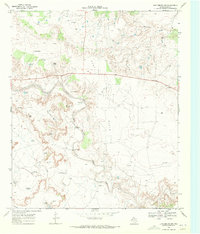
1969 Map of Cap Rock SE
USGS Topo · Published 1971About this map
The Salt Fork Brazos River and the Double Mountain Fork Brazos River dominate this West Texas landscape, showing a complex network of drainage and relief in Garza County. At the end of the 1960s, the region's topography was increasingly defined by the industrial infrastructure of the petroleum era. Multiple Oil Wells, a Drill Hole, and an Aqueduct crossing the terrain highlight the local economy's reliance on water management and resource extraction. Smaller details like a solitary Grave and a Water Tank provide the kind of specific, hyper-local landmarks essential for genealogical research and historical recreation. This survey captures a moment where the natural watercourses like Lake Creek and Falls Creek intersected with growing human engineering in the High Plains.
Find a feature on this map
12 named features on this map. Tap any name to fly to it.
Don’t see what you’re looking for? This feature index may not catch every label — zoom into the map to look around manually.
Map Details
Editions of this 1969 Cap Rock SE Map
This is the sole edition of this map. No revisions or reprints were ever made.
Other maps of this area

1954 · Lubbock
USGS Topo · 1:250,000

1966 · Cap Rock
USGS Topo · 1:24,000

1966 · Kalgary
USGS Topo · 1:24,000

1966 · Canyon Valley
USGS Topo · 1:24,000

1968 · South Dokegood Creek
USGS Topo · 1:24,000

1969 · Verbena
USGS Topo · 1:24,000
1969 · Justiceburg NW
USGS Topo · 1:24,000

1969 · Post East
USGS Topo · 1:24,000

1969 · Post West
USGS Topo · 1:24,000
1986 · Slaton
USGS Topo · 1:100,000