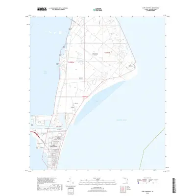
2018 Map of Cape Canaveral
USGS Topo · Published 2018About this map
Canaveral Peninsula forms a distinctive barrier between the Indian River Lagoon and the Atlantic Ocean in this 2018 survey. The landscape is dominated by the intersection of aerospace infrastructure and coastal waterways, featuring the Cape Canaveral Air Force Station Skid Strip and a dense network of roads reflecting its mid-century development, such as Astronaut Blvd and NASA Pkwy E. The residential and commercial layout of Cape Canaveral sits just south of the Canaveral Barge Canal, where a grid of streets like Washington Ave and Fillmore Ave meet the coast near Jetty Park Rd. Further north, the terrain remains less developed, characterized by points and coves along the Banana River shore, including Peterson Point, Cactus Point, and the secluded Alligator Pond.
Find a feature on this map
93 named features on this map. Tap any name to fly to it.
Don’t see what you’re looking for? This feature index may not catch every label — zoom into the map to look around manually.
Map Details
Editions of this 2018 Cape Canaveral Map
This is the sole edition of this map. No revisions or reprints were ever made.
Other maps of this area

1949 · Orsino
USGS Topo · 1:24,000

1949 · False Cape
USGS Topo · 1:24,000

1949 · Courtenay
USGS Topo · 1:24,000

1949 · Cocoa
USGS Topo · 1:24,000

1949 · Cocoa Beach
USGS Topo · 1:24,000

1951 · False Cape
USGS Topo · 1:24,000

1951 · Cocoa
USGS Topo · 1:24,000

1951 · Courtenay
USGS Topo · 1:24,000
1951 · Cocoa Beach
USGS Topo · 1:24,000

1951 · Orsino
USGS Topo · 1:24,000